High Clouds
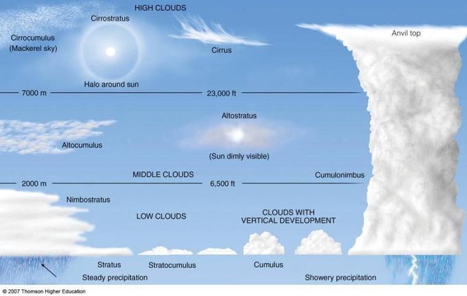
High clouds form high in the atmosphere, starting at 23,000 feet (7,000 meters).
Cirrus
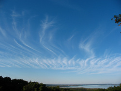
Cirrus clouds are thin, whispy clouds that are blown by high winds into long streamers called "mares' tales".
They usually move across the sky in the direction of the prevailing winds at their elevation.
They usually move across the sky in the direction of the prevailing winds at their elevation.
Cirrostratus
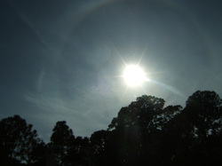
Cirrostratus clouds are thin, sheetlike clouds that often cover the entire sky.
They are so thin that the sun and moon can be clearly seen through them.
These clouds are formed from ice crystals, and the ice crystals in the clouds bend the light passing through them to create a halo that encircles the sun or moon. In face, sometimes cirrostratus clouds are so thin that the halo is the only clue to their presence.
They can be used to predict rain or snow within 12 to 24 hours.
Cirrocumulus
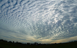
Cirrocumulus clouds appear as small, rounded white puffs that may occur individually, or in long rows.
They usually only cover a small portion of the sky.
The small ripples in these clouds resemble scales of a fish and are therefore often referred to as a "mackrel sky".
They usually only cover a small portion of the sky.
The small ripples in these clouds resemble scales of a fish and are therefore often referred to as a "mackrel sky".
